2.4 Geological frame of this study
| These
crystalline rocks form as it were a wide arch or roof, with its apex
greatly eroded and worn away, now mostly buried under masses of snow
and ice. [...] Whilst the Southern range of the Central Himalayas
is formed chiefly of crystalline rocks, mostly gneissic with metamorphic
schists, it is shown that the Northern range is almost entirely composed
of a vast sequence of sedimentary strata, ranging from the lower Palaeozoic
to Tertiary and recent age [...] Between the Crystalline rocks and
the next following, clearly sedimentary rocks, a clearly defined boundary
scarcely exists. In nearly all sections I have hitherto examined,
the schists seem to pass gradually into the overlying slates, phyllites
and quartzites of the overlying Haimantas (Phe Fm.).
Griesbach, 1891 |
This study is focused on the Central Himalayan Domain in the southwestern part of Zanskar and encompasses the upper part of the High Himalayan Crystalline Sequence as well as the Proterozoic to Triassic sedimentary formations of the Tethys Himalaya. (see map of the studied area)
Already on the basis of satellite imagery (Fig. 2.3 ), a clear topographic distinction can be made between these two contrasting domains. The HHCS forms the snow-capped towering peaks of the Great Himalayan Range, stretching along the southwestern side of the main Doda-Lingti-Kurgiakh valley. On the northeastern side of this valley, the varicoloured sedimentary formations of the Tethys Himalaya build up the smoothly shaped relief of the Zanskar Range.
The High Himalayan Crystalline Sequence of Zanskar is composed of metapelites and metapsammites, ortho- and paragneisses as well as minor calcsilicates and metabasites, cross-cut by Tertiary leucogranitic intrusions.
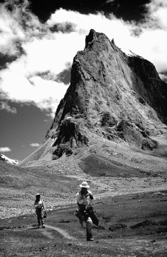
The structurally deepest zone of the HHCS in the studied area is formed of migmatitic orthogneisses and paragneisses, metamorphosed at upper amphibolite to granulite facies conditions. The overlying rather hornfelsic gneisses are injected by a dense network of leucogranitic dikes which ascend vertically over a distance of several hundred metres. These leucogranitic dikes are rooted into the migmatitic zone and thus seem to originate from the partial melting of these rocks. Towards the top of the HHCS, these dikes sometimes coalesce to form a ~1 kilometre thick sheet of massive leucogranitic plutons containing only scarce bits of country rocks. Although leucogranitic dikes are present all over the HHCS of Zanskar, the studied area distinguishes itself by their abundance. A striking example of these intrusions is illustrated by the snow-white cliffs of the Gumburanjun mountain (Fig. 2.4) , situated in the middle of the studied area. This awe-inspiring mountain, shaped like the oversized prow of a gigantic ship, is indeed essentially carved out of leucogranitic rocks. The high-grade metamorphic rocks that make up the core of the HHCS form an elongated domal structure in Zanskar. The studied area is situated at the southeastern end of this domal structure which then disappears in the Sarchu region under the Tethys Himalaya. Therefore, the last leucogranitic intrusions crop out in this area and do not show up in the adjacent Lahul area.
The leucogranitic belt is surmounted by a major tectonic structure, the Zanskar Shear Zone. This structure corresponds to an approximately one kilometre thick mylonitic zone dipping 20° to the northeast. The Zanskar Shear Zone represents a 150-kilometres-long segment of the Central Himalayan Detachment System that runs intermittently between the HHCS and the TH along the entire length of the Himalaya. In Zanskar, this shear zone follows quite systematically the main Doda-Lingti-Kurgiakh valley for most of its length and marks the gradual passage between the high-grade metamorphic rocks of the HHCS and the weakly metamorphosed sediments of the Tethys Himalaya. Within this narrow zone of ductile deformation, a gradual transition between these two tectonometamorphic units is marked by a very rapid decrease of the metamorphic gradient from amphibolite facies at the base of the ZSZ to lower greenschist at its top. This is attested by the presence of a comlete, although very condensed, Barrovian succession of kyanite, staurolite, garnet, biotite and chlorite mineral zones within the metapelitic schists of the Zanskar Shear Zone. The sedimentary formations of the Tethys Himalaya then form the hanging wall of the Zanskar Shear Zone. This gradual, though rapid, metamorphic tranition indicates, as already observed by Griesbach (1891) for the Spiti and Sutlej regions, that the sediments from the lowermost Tethys Himalaya represent the protolith of the High Himalayan Crystaline Sequence metasediments and that a clearly defined boundary scarcely exists between these two zones. In Zanskar however, the aspect of this gradual transition between the HHCS and the TH depends on the nature of the rocks occurring within the Zanskar Shear Zone. In those regions where these rocks are schistose, the transition is nearly perfect. Yet, in other regions as near Mune, where the rocks at the top of the HHCS are gneissic, a slickenside separates the HHCS from the TH. Structural analyses reveal that the Zanskar Shear Zone corresponds to a top to the northeast extensional shear zone which reactivates, in an opposite direction, older structures associated to the southwestward thrusting of the Nyimaling-Tsarap nappe. Nearly all the sedimentary formations of the Tethys Himalaya are present in the southeastern part of the studied area. These formations, ranging from upper Proterozoic to Triassic are however often much less developed than in the adjacent Spiti or Lahul basins. Moreover, most of the Paleozoic formations continue to thin up towards the northeast of the studied area, until most of them totally disappear in the region of Tanze and are never to be seen again along the Zanskar range. The Tethys Himalaya in Zanskar represents the frontal part of a large-scale southwest-verging imbricate structure nappe. Several younger high-angle extensional normal faults cut through the sedimentary formations. These faults sometimes account for large relative vertical displacements as in the Sarchu region (Spring, 1993).
|
|
Fig. 2.4.: The Gumburanjun mountain at the headwater of the Kurgiakh river. Its more than 1000 m high cliffs are almost entirely carved out of leucogranites. View from the north towards the south. |